Difference between revisions of "January 24, 2006"

From LPOD
Jump to: navigation, search
Line 1: Line 1:
 
__NOTOC__
 
__NOTOC__
 
=Fecund Questions=
 
=Fecund Questions=
 +
<div class="post" id="post-29">
  
+
<div class="storycontent">
<div class="post" id="post-29">
+
<p>[[File:Fecund-Pau.jpg|Fecunditatis by K.C. Pau]]<br />
 
<div class="storycontent">
 
<p>[[File:Fecund-Pau.jpg|Fecunditatis by K.C. Pau]]<br />
 
 
<em>image by [mailto:kcpaulhk@yahoo.com.hk/  K.C. Pau]</em></p>
 
<em>image by [mailto:kcpaulhk@yahoo.com.hk/  K.C. Pau]</em></p>
 
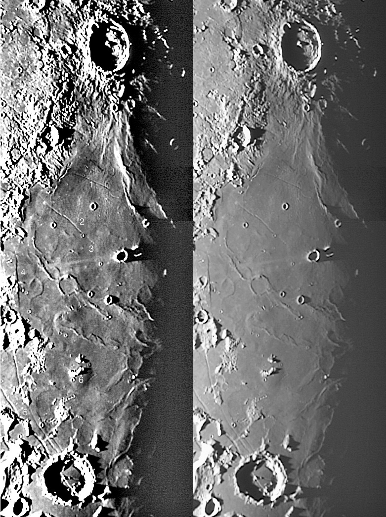
<p>Sometimes we observe with our eyes closed. Or so it seems. How many times have you observed or imaged Messier and its parallel rays without looking carefully at the underlying Mare Fecunditatis? In a lovely low sun mosaic (right) that I have extravagantly enhanced (left), K.C. Pau has documented a much more complex mare surface than we normally see. From the crater Taruntius in the north (top) to Goclenius at the south (bottom) there are rilles (#1, 2 &#038; 5), a fault (#4), low mare ridges and ghost craters (too many to number) and swells (#6). One thing I had never noticed before is that the Messier Rille (#2) stops exactly at a curved boundary (#3). Is the area to the right of the boundary higher and younger than the mare surface cut by rille #2? Does the material to the right bury the right end of the rille? Move south to the teardrop-shaped swell (#6) surrounding some hills (relict from what?). Why do low swells often surround isolated hills? Do they mark high levels of the original mare surface that was lowered as gases escaped the cooling lavas? This happens in Hawaii but on a horizontal scale of a few meters rather than tens of kilometers! Finally, what controls the orientations and locations of mare ridges in Fecunditatis? In Serenitatis and other places, mare ridges often define circular inner rings of impact basins, but the ridges of central and western Fecunditatis are roughly radial to the center of the basin. These are a lot of good questions to be provoked by a single mosaic!</p>
 
<p>Sometimes we observe with our eyes closed. Or so it seems. How many times have you observed or imaged Messier and its parallel rays without looking carefully at the underlying Mare Fecunditatis? In a lovely low sun mosaic (right) that I have extravagantly enhanced (left), K.C. Pau has documented a much more complex mare surface than we normally see. From the crater Taruntius in the north (top) to Goclenius at the south (bottom) there are rilles (#1, 2 &#038; 5), a fault (#4), low mare ridges and ghost craters (too many to number) and swells (#6). One thing I had never noticed before is that the Messier Rille (#2) stops exactly at a curved boundary (#3). Is the area to the right of the boundary higher and younger than the mare surface cut by rille #2? Does the material to the right bury the right end of the rille? Move south to the teardrop-shaped swell (#6) surrounding some hills (relict from what?). Why do low swells often surround isolated hills? Do they mark high levels of the original mare surface that was lowered as gases escaped the cooling lavas? This happens in Hawaii but on a horizontal scale of a few meters rather than tens of kilometers! Finally, what controls the orientations and locations of mare ridges in Fecunditatis? In Serenitatis and other places, mare ridges often define circular inner rings of impact basins, but the ridges of central and western Fecunditatis are roughly radial to the center of the basin. These are a lot of good questions to be provoked by a single mosaic!</p>
Line 14: Line 12:
 
<strong>Related Links:</strong><br />
 
<strong>Related Links:</strong><br />
 
Rükl charts 37 &#038; 38</p>
 
Rükl charts 37 &#038; 38</p>
</div>
+
</div>


----
 
----
 
===COMMENTS?===  
 
===COMMENTS?===  
 
Click on this icon [[image:PostIcon.jpg]] at the upper right to post a comment.
 
Click on this icon [[image:PostIcon.jpg]] at the upper right to post a comment.

Revision as of 18:33, 4 January 2015

Fecund Questions

Fecunditatis by K.C. Pau
image by K.C. Pau

Sometimes we observe with our eyes closed. Or so it seems. How many times have you observed or imaged Messier and its parallel rays without looking carefully at the underlying Mare Fecunditatis? In a lovely low sun mosaic (right) that I have extravagantly enhanced (left), K.C. Pau has documented a much more complex mare surface than we normally see. From the crater Taruntius in the north (top) to Goclenius at the south (bottom) there are rilles (#1, 2 & 5), a fault (#4), low mare ridges and ghost craters (too many to number) and swells (#6). One thing I had never noticed before is that the Messier Rille (#2) stops exactly at a curved boundary (#3). Is the area to the right of the boundary higher and younger than the mare surface cut by rille #2? Does the material to the right bury the right end of the rille? Move south to the teardrop-shaped swell (#6) surrounding some hills (relict from what?). Why do low swells often surround isolated hills? Do they mark high levels of the original mare surface that was lowered as gases escaped the cooling lavas? This happens in Hawaii but on a horizontal scale of a few meters rather than tens of kilometers! Finally, what controls the orientations and locations of mare ridges in Fecunditatis? In Serenitatis and other places, mare ridges often define circular inner rings of impact basins, but the ridges of central and western Fecunditatis are roughly radial to the center of the basin. These are a lot of good questions to be provoked by a single mosaic!

Chuck Wood

Technical Details:
24 July 2005, 250mm f/6 Newtonian reflector + 2.5X Barlow + Philips Toucam Pro; mosaic of 4 images.
Related Links:
Rükl charts 37 & 38


COMMENTS?

Click on this icon File:PostIcon.jpg at the upper right to post a comment.