Difference between revisions of "September 10, 2012"
| (2 intermediate revisions by the same user not shown) | |||
| Line 6: | Line 6: | ||
<em>image by [mailto:motomaro@ga2.so-net.ne.jp 白尾 元理] (Motomaro Shirao)</em><br /> | <em>image by [mailto:motomaro@ga2.so-net.ne.jp 白尾 元理] (Motomaro Shirao)</em><br /> | ||
<br /> | <br /> | ||
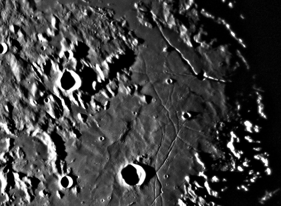
| − | Moto's view of the Triesnecker-Hyginus nicely shows many of the rilles recently seen on an LRO [http://lpod. | + | Moto's view of the Triesnecker-Hyginus nicely shows many of the rilles recently seen on an LRO [http://www2.lpod.org/wiki/September_2,_2012 mosaic] but the low Sun also reveals undulations of the surface, including the [[October_19,_2007|trough]]north and east of Triesnecker. A larger diagonal region of relatively smooth - compared to cratered regions to the top left and bottom right - material crossed by the rilles looks like a depression filled with smooth material. Is this entire 175 km wide area from Sinus Medii to Hyginus a mega-trough? Did it subside and get filled by the smooth material? And what is the material? We know that in some places at least, there is [[November_4,_2006|mare lava]] under the lighter hued covering, which may be Imbrium ejecta. I propose that the broad Triesnecker trough is, like Insularum, Medii, Vaporum and Frigoris, part of the annular depression that surrounds much of the Imbrium Basin. This annular region could be a moat between the Apennine ring and a more distant one (the edge of the southern highlands?), or it could be inside an inner ring of the Procellarum Basin. If the broad Triesnecker trough subsided a little after the lava and other fill solidified then extension could have pulled open the rilles that parallel the trough edges. The rilles are mostly on the east side so perhaps, like asymmetric basins of the East African Rift Valley, the subsidence was greater on one side than the other. The LRO Path tool shows that the rilles follow a ridge dipping down to the low trough to the west. Does this explain the Triesnecker Rilles?<br /> |
<br /> | <br /> | ||
<em>[mailto:tychocrater@yahoo.com Chuck Wood]</em><br /> | <em>[mailto:tychocrater@yahoo.com Chuck Wood]</em><br /> | ||
| Line 14: | Line 14: | ||
<br /> | <br /> | ||
<strong>Related Links</strong><br /> | <strong>Related Links</strong><br /> | ||
| − | Rükl plate [ | + | Rükl plate [https://the-moon.us/wiki/R%C3%BCkl_33 33]<br /> |
<br /> | <br /> | ||
<p><b>Yesterday's LPOD:</b> [[September 9, 2012|Jules Updated]] </p> | <p><b>Yesterday's LPOD:</b> [[September 9, 2012|Jules Updated]] </p> | ||
Latest revision as of 08:36, 28 October 2018
Explanation?

image by 白尾 元理 (Motomaro Shirao)
Moto's view of the Triesnecker-Hyginus nicely shows many of the rilles recently seen on an LRO mosaic but the low Sun also reveals undulations of the surface, including the troughnorth and east of Triesnecker. A larger diagonal region of relatively smooth - compared to cratered regions to the top left and bottom right - material crossed by the rilles looks like a depression filled with smooth material. Is this entire 175 km wide area from Sinus Medii to Hyginus a mega-trough? Did it subside and get filled by the smooth material? And what is the material? We know that in some places at least, there is mare lava under the lighter hued covering, which may be Imbrium ejecta. I propose that the broad Triesnecker trough is, like Insularum, Medii, Vaporum and Frigoris, part of the annular depression that surrounds much of the Imbrium Basin. This annular region could be a moat between the Apennine ring and a more distant one (the edge of the southern highlands?), or it could be inside an inner ring of the Procellarum Basin. If the broad Triesnecker trough subsided a little after the lava and other fill solidified then extension could have pulled open the rilles that parallel the trough edges. The rilles are mostly on the east side so perhaps, like asymmetric basins of the East African Rift Valley, the subsidence was greater on one side than the other. The LRO Path tool shows that the rilles follow a ridge dipping down to the low trough to the west. Does this explain the Triesnecker Rilles?
Chuck Wood
Technical Details
2012/09/07 17h40m UT. 35cm Rl. f 2100mm + rojection lens: Pentax XP 14mm + Canon EOS 5D Mark III ISO1600 1/4 sec.
Related Links
Rükl plate 33
Yesterday's LPOD: Jules Updated
Tomorrow's LPOD: Unlucky in Location
COMMENTS?
Register, Log in, and join in the comments.


