Difference between revisions of "April 27, 2005"
| (8 intermediate revisions by the same user not shown) | |||
| Line 1: | Line 1: | ||
__NOTOC__ | __NOTOC__ | ||
=A Busy Place= | =A Busy Place= | ||
| + | <!-- Start of content --> | ||
<table width="85%" border="0" align="center" cellpadding="6" cellspacing="2"> | <table width="85%" border="0" align="center" cellpadding="6" cellspacing="2"> | ||
<tr> | <tr> | ||
| − | |||
</tr> | </tr> | ||
</table> | </table> | ||
| Line 13: | Line 13: | ||
</table> | </table> | ||
<table width="80%" border="0" align="center" cellpadding="8"> | <table width="80%" border="0" align="center" cellpadding="8"> | ||
| − | <tr><td><div align="center" class="main_sm">Image Credit: [http://www.lpi.usra.edu/resources/apollo/catalog/70mm/magazine/?151 Apollo 15 151-23268]</p> | + | <tr><td><div align="center" class="main_sm"><p>Image Credit: [http://www.lpi.usra.edu/resources/apollo/catalog/70mm/magazine/?151 Apollo 15 151-23268]</p> |
</div></td> | </div></td> | ||
</tr> | </tr> | ||
| Line 22: | Line 22: | ||
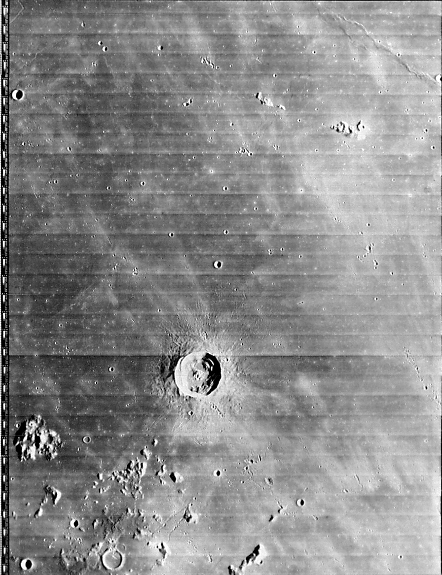
<p align="left">We think of Imbrium as a vast sheet of lava (or lavas), mostly cleanly fringed by the Apennines and other mountain boundaries. This may be a false impression resulting from a lack of high resolution images! In this Apollo Hasselblad image recommended by Danny Caes we can see a part of Imbrium just north of the Carpathian Mts that has had a more complex history than simple flows of lava. The large unnamed mountain (Caes Mt?) at right center is rather far from the Carpathians to be considered part of that range, instead it seems related to the hills to the left (west). This is a 100 km expanse of rough terrain that might be equivalent to the [[August_31,_2004|Apennine Bench Formation]] near Archimedes. This moderate sun handheld Apollo shot shows features not seen in the Lunar Orbiter IV view of the same area. A segment of a wide linear rille is just left of Caes Mt. - it looks like it might continue to the two small linear peaks to the upper right. Natasha is the broad, flat-floored crater to the left center; below and to the left of this crater is a dome with an off-center elongated pit. To the lower right of Natasha there is a pancake-like dome or swell. This area is sprinkled with chains of secondary craters from Copernicus, and there are two crater chains not from Copernicus above Natasha. I hope to soon see a high resolution, low sun amateur image of this area! | <p align="left">We think of Imbrium as a vast sheet of lava (or lavas), mostly cleanly fringed by the Apennines and other mountain boundaries. This may be a false impression resulting from a lack of high resolution images! In this Apollo Hasselblad image recommended by Danny Caes we can see a part of Imbrium just north of the Carpathian Mts that has had a more complex history than simple flows of lava. The large unnamed mountain (Caes Mt?) at right center is rather far from the Carpathians to be considered part of that range, instead it seems related to the hills to the left (west). This is a 100 km expanse of rough terrain that might be equivalent to the [[August_31,_2004|Apennine Bench Formation]] near Archimedes. This moderate sun handheld Apollo shot shows features not seen in the Lunar Orbiter IV view of the same area. A segment of a wide linear rille is just left of Caes Mt. - it looks like it might continue to the two small linear peaks to the upper right. Natasha is the broad, flat-floored crater to the left center; below and to the left of this crater is a dome with an off-center elongated pit. To the lower right of Natasha there is a pancake-like dome or swell. This area is sprinkled with chains of secondary craters from Copernicus, and there are two crater chains not from Copernicus above Natasha. I hope to soon see a high resolution, low sun amateur image of this area! | ||
</p> | </p> | ||
| − | <blockquote><p align="right">— [mailto:tychocrater@yahoo.com Chuck Wood]</blockquote> | + | <blockquote> |
| − | <p align="left" | + | <p align="right">— [mailto:tychocrater@yahoo.com Chuck Wood]</p></blockquote> |
| − | [ | + | <p align="left"><b>Related Links:</b><br> |
| − | <p | + | [http://www.lpi.usra.edu/resources/lunar_orbiter/images/img/iv_133_h3.jpg Lunar Orbiter IV View ] |
| + | </p> | ||
| + | <p><b>Yesterday's LPOD:</b> [[April 26, 2005|More Spectacular Flows in Imbrium]] </p> | ||
| + | <p><b>Tomorrow's LPOD:</b> [[April 28, 2005|Red Moon (and Blue Too)]] </p> | ||
</tr> | </tr> | ||
</table> | </table> | ||
| Line 36: | Line 39: | ||
<p align="center" class="main_titles"><b>Author & Editor:</b><br> | <p align="center" class="main_titles"><b>Author & Editor:</b><br> | ||
[mailto:tychocrater@yahoo.com Charles A. Wood]</p> | [mailto:tychocrater@yahoo.com Charles A. Wood]</p> | ||
| − | < | + | <!-- Cleanup of credits --> |
| − | + | <!-- Cleanup of credits --> | |
| − | < | + | <!-- Cleanup of credits --> |
| − | + | <!-- Cleanup of credits --> | |
| − | + | <!-- Cleanup of credits --> | |
| − | < | + | <!-- Cleanup of credits --> |
| − | < | + | <!-- Cleanup of credits --> |
| − | + | <!-- Cleanup of credits --> | |
| − | < | + | <!-- Cleanup of credits --> |
| − | + | <!-- Cleanup of credits --> | |
</td></tr> | </td></tr> | ||
</table> | </table> | ||
<p> </p> | <p> </p> | ||
| − | ---- | + | <!-- End of content --> |
| − | + | {{wiki/ArticleFooter}} | |
| − | |||
Latest revision as of 15:14, 15 March 2015
A Busy Place
|

Image Credit: Apollo 15 151-23268 |
|
A Busy Place We think of Imbrium as a vast sheet of lava (or lavas), mostly cleanly fringed by the Apennines and other mountain boundaries. This may be a false impression resulting from a lack of high resolution images! In this Apollo Hasselblad image recommended by Danny Caes we can see a part of Imbrium just north of the Carpathian Mts that has had a more complex history than simple flows of lava. The large unnamed mountain (Caes Mt?) at right center is rather far from the Carpathians to be considered part of that range, instead it seems related to the hills to the left (west). This is a 100 km expanse of rough terrain that might be equivalent to the Apennine Bench Formation near Archimedes. This moderate sun handheld Apollo shot shows features not seen in the Lunar Orbiter IV view of the same area. A segment of a wide linear rille is just left of Caes Mt. - it looks like it might continue to the two small linear peaks to the upper right. Natasha is the broad, flat-floored crater to the left center; below and to the left of this crater is a dome with an off-center elongated pit. To the lower right of Natasha there is a pancake-like dome or swell. This area is sprinkled with chains of secondary craters from Copernicus, and there are two crater chains not from Copernicus above Natasha. I hope to soon see a high resolution, low sun amateur image of this area! Related Links: Yesterday's LPOD: More Spectacular Flows in Imbrium Tomorrow's LPOD: Red Moon (and Blue Too) |
|
Author & Editor: |
COMMENTS?
Register, Log in, and join in the comments.


