Difference between revisions of "August 8, 2014"
| (One intermediate revision by the same user not shown) | |||
| Line 1: | Line 1: | ||
__NOTOC__ | __NOTOC__ | ||
=Pyrenees Panorama= | =Pyrenees Panorama= | ||
| + | <!-- Start of content --> | ||
<!-- ws:start:WikiTextHeadingRule:0:<h1> --> | <!-- ws:start:WikiTextHeadingRule:0:<h1> --> | ||
<!-- ws:start:WikiTextLocalImageRule:14:<img src="/file/view/LPOD-Aug8-14.jpg/518013238/LPOD-Aug8-14.jpg" alt="" title="" /> -->[[File:LPOD-Aug8-14.jpg|LPOD-Aug8-14.jpg]]<!-- ws:end:WikiTextLocalImageRule:14 --><br /> | <!-- ws:start:WikiTextLocalImageRule:14:<img src="/file/view/LPOD-Aug8-14.jpg/518013238/LPOD-Aug8-14.jpg" alt="" title="" /> -->[[File:LPOD-Aug8-14.jpg|LPOD-Aug8-14.jpg]]<!-- ws:end:WikiTextLocalImageRule:14 --><br /> | ||
| Line 8: | Line 9: | ||
<td><!-- ws:start:WikiTextLocalImageRule:15:<img src="/file/view/LPOD-Aug8-14b.jpg/518014658/LPOD-Aug8-14b.jpg" alt="" title="" /> -->[[File:LPOD-Aug8-14b.jpg|LPOD-Aug8-14b.jpg]]<!-- ws:end:WikiTextLocalImageRule:15 --><br /> | <td><!-- ws:start:WikiTextLocalImageRule:15:<img src="/file/view/LPOD-Aug8-14b.jpg/518014658/LPOD-Aug8-14b.jpg" alt="" title="" /> -->[[File:LPOD-Aug8-14b.jpg|LPOD-Aug8-14b.jpg]]<!-- ws:end:WikiTextLocalImageRule:15 --><br /> | ||
</td> | </td> | ||
| − | <td>Yesterday we saw a [http://lpod. | + | <td>Yesterday we saw a [http://www2.lpod.org/wiki/August_7,_2014 map] of the Mare Nectaris lavas, and today's LPOD features a near terminator view of the less frequently seen northern and eastern margins of the basin. Moïse's first LPOD is quite a good image, with excellent detail for the Guttenberg Rilles and the craters in front of the Pyrenees Mountains, which curve from Bohnenberger (B) almost to Capella (C). Pretty much all of the edges of Mare Nectaris - except for near Theophilus - are full of partially or fully flooded craters, often with lowered or missing mare-facing rims. Daguerre (D) and nearby crater ruins are heavily modified examples. The flooding was due to tilting of the surface the craters formed on as the center of the basin subsided from the weight of the lavas. Half way between D and B is a small crater in the mare that is little more than a rim with an off-center hilly mass. LRO NAC [http://bit.ly/1pFccTh images] show it more sharply, but don't help much in understanding why the hills are there. Perhaps the hills are remnants of a floor-fractured interior as occurs [http://bit.ly/1sD3bMB nearby] at Gaudibert and two near it, and Bohnenberger further south. Considering the likelihood that Daguerre had a volcanic [http://www.lpod.org/archive/LPOD-2004-10-23.htm past], and that floor-fractured craters did too, the relatively limited mare expanse of Nectaris may mislead us from a more extensive volcanic history.<br /> |
<br /> | <br /> | ||
<em>[mailto:tychocrater@yahoo.com Chuck Wood]</em><br /> | <em>[mailto:tychocrater@yahoo.com Chuck Wood]</em><br /> | ||
| Line 16: | Line 17: | ||
<br /> | <br /> | ||
<strong>Related Links</strong><br /> | <strong>Related Links</strong><br /> | ||
| − | <em>[ | + | <em>[[21st Century Atlas of the Moon|21st Century Atlas]]</em> charts 6 & 7.<br /> |
</td> | </td> | ||
</tr> | </tr> | ||
Latest revision as of 08:24, 28 October 2018
Pyrenees Panorama

image by Moïse Flückiger, Switzerland
 |
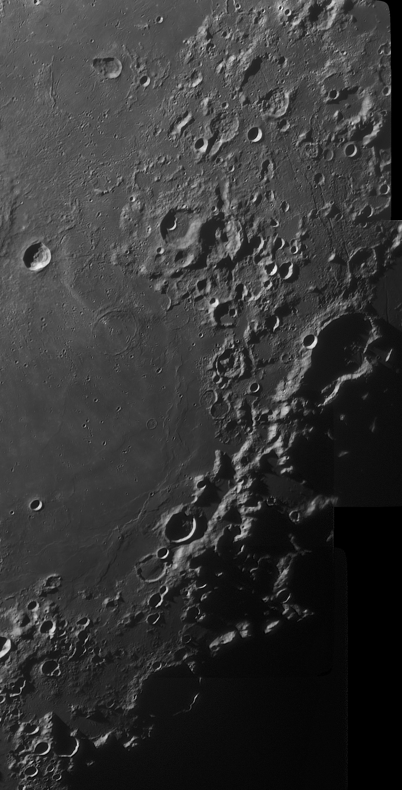
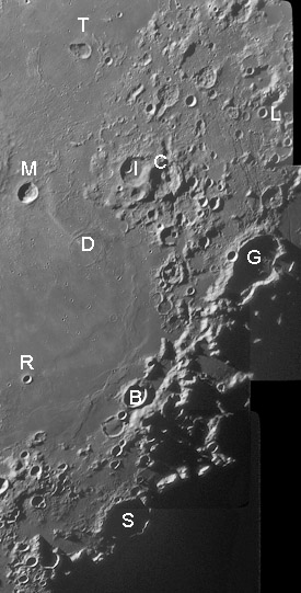
Yesterday we saw a map of the Mare Nectaris lavas, and today's LPOD features a near terminator view of the less frequently seen northern and eastern margins of the basin. Moïse's first LPOD is quite a good image, with excellent detail for the Guttenberg Rilles and the craters in front of the Pyrenees Mountains, which curve from Bohnenberger (B) almost to Capella (C). Pretty much all of the edges of Mare Nectaris - except for near Theophilus - are full of partially or fully flooded craters, often with lowered or missing mare-facing rims. Daguerre (D) and nearby crater ruins are heavily modified examples. The flooding was due to tilting of the surface the craters formed on as the center of the basin subsided from the weight of the lavas. Half way between D and B is a small crater in the mare that is little more than a rim with an off-center hilly mass. LRO NAC images show it more sharply, but don't help much in understanding why the hills are there. Perhaps the hills are remnants of a floor-fractured interior as occurs nearby at Gaudibert and two near it, and Bohnenberger further south. Considering the likelihood that Daguerre had a volcanic past, and that floor-fractured craters did too, the relatively limited mare expanse of Nectaris may mislead us from a more extensive volcanic history.
|
Yesterday's LPOD: What Lunar Scientists Do
Tomorrow's LPOD: A Course Full of Input
COMMENTS?
Register, Log in, and join in the comments.


