Difference between revisions of "July 4, 2009"
| Line 3: | Line 3: | ||
<!-- ws:start:WikiTextHeadingRule:2:<h1> --> | <!-- ws:start:WikiTextHeadingRule:2:<h1> --> | ||
<!-- ws:start:WikiTextLocalImageRule:8:<img src="/file/view/LPOD-July4-09.jpg/80260933/LPOD-July4-09.jpg" alt="" title="" /> -->[[File:LPOD-July4-09.jpg|LPOD-July4-09.jpg]]<!-- ws:end:WikiTextLocalImageRule:8 --><br /> | <!-- ws:start:WikiTextLocalImageRule:8:<img src="/file/view/LPOD-July4-09.jpg/80260933/LPOD-July4-09.jpg" alt="" title="" /> -->[[File:LPOD-July4-09.jpg|LPOD-July4-09.jpg]]<!-- ws:end:WikiTextLocalImageRule:8 --><br /> | ||
| − | <em>image by [http://arecibo.tc.cornell.edu/lunarimages/default.aspx | + | <em>image by [http://arecibo.tc.cornell.edu/lunarimages/default.aspx Courtesy Cornell University/Smithsonian Institution] with names added by CAW</em><br /> |
<br /> | <br /> | ||
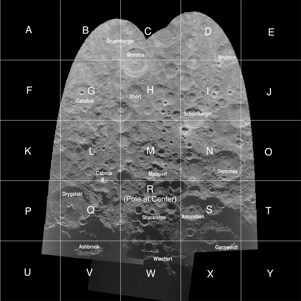
| − | Over the last 40 years radar pulses have been bounced off the Moon to produce images of ever greater resolution. This mosaic is the index of the largest high resolution radar data yet acquired. It is about 60,000 by 60,000 pixels in size and maps at 20 m resolution the region from just beyond the South Pole to this side of Moretus. If this looks familiar it is because it is an extension of previously released [http://www.lpod.org/?m=20061107 | + | Over the last 40 years radar pulses have been bounced off the Moon to produce images of ever greater resolution. This mosaic is the index of the largest high resolution radar data yet acquired. It is about 60,000 by 60,000 pixels in size and maps at 20 m resolution the region from just beyond the South Pole to this side of Moretus. If this looks familiar it is because it is an extension of previously released [http://www.lpod.org/?m=20061107 version] centered on the pole. The illumination angle increases southward from the equivalent of 'Full Moon" to "terminator" but provides less shadowing at the pole than typical of Sun-illuminated scenes. The images were constructed from S-band radar (a wavelength of 12.6 cm) data with signals transmitted from the big dish at Arecibo and the echoes received in the hills of West Virginia at the Green Bank radio observatory. Because each of the individual mosaic panes (labeled A to Y) is huge (often over 100 Mb) I have reduced their sizes by a factor of ten and [http://the-moon.wikispaces.com/Cornell-Smithsonian+Radar+Mosaic added] these more manageable files on the Moon-Wiki. I have also started to add names and letter designations to the [http://the-moon.wikispaces.com/South+Pole-D panes] based on the IAU approved nomenclature in the <em>[http://the-moon.wikispaces.com/System+of+Lunar+Craters System of Lunar Craters]</em>. This is quite difficult for the designations are based on what seems prominent as seen from the Earth and usually at low Sun angles. Some of the features do not appear to warrant letters based on this image, but they often appear OK when seen on good Earth images. This is a good example that nomenclature assignments should not be based on any single image! Thanks to the unrelated Don Campbell at Cornell and Bruce Campbell at Smithsonian for releasing this great resource!<br /> |
<br /> | <br /> | ||
| − | <em>[mailto:tychocrater@yahoo.com | + | <em>[mailto:tychocrater@yahoo.com Chuck Wood]</em><br /> |
<br /> | <br /> | ||
<strong>Related Links</strong><br /> | <strong>Related Links</strong><br /> | ||
Revision as of 19:00, 17 January 2015
No Z

image by Courtesy Cornell University/Smithsonian Institution with names added by CAW
Over the last 40 years radar pulses have been bounced off the Moon to produce images of ever greater resolution. This mosaic is the index of the largest high resolution radar data yet acquired. It is about 60,000 by 60,000 pixels in size and maps at 20 m resolution the region from just beyond the South Pole to this side of Moretus. If this looks familiar it is because it is an extension of previously released version centered on the pole. The illumination angle increases southward from the equivalent of 'Full Moon" to "terminator" but provides less shadowing at the pole than typical of Sun-illuminated scenes. The images were constructed from S-band radar (a wavelength of 12.6 cm) data with signals transmitted from the big dish at Arecibo and the echoes received in the hills of West Virginia at the Green Bank radio observatory. Because each of the individual mosaic panes (labeled A to Y) is huge (often over 100 Mb) I have reduced their sizes by a factor of ten and added these more manageable files on the Moon-Wiki. I have also started to add names and letter designations to the panes based on the IAU approved nomenclature in the System of Lunar Craters. This is quite difficult for the designations are based on what seems prominent as seen from the Earth and usually at low Sun angles. Some of the features do not appear to warrant letters based on this image, but they often appear OK when seen on good Earth images. This is a good example that nomenclature assignments should not be based on any single image! Thanks to the unrelated Don Campbell at Cornell and Bruce Campbell at Smithsonian for releasing this great resource!
Chuck Wood
Related Links
Rükl plates 72 & 73


