|
|
| Line 1: |
Line 1: |
| | __NOTOC__ | | __NOTOC__ |
| − | =Another Kind of Mapping= | + | =Layers of History= |
| − | Originally published February 10, 2006 | + | Originally published February 9, 2006 |
| | <!-- Start of content --> | | <!-- Start of content --> |
| − | <div class="post" id="post-71"> | + | <div class="post" id="post-68"> |
| | | | |
| | <div class="storycontent"> | | <div class="storycontent"> |
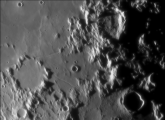
| − | <p>[[File:CopernicusGeolMap.jpg|Copernicus GeoMap]]<br /> | + | <p>[[File:Rima_Oppolzer_rima_Reaumur_sbar.jpg|Rimae Oppol&Reaumur-Sbarufatti]]<br /> |
| − | <em>[http://www.lpi.usra.edu/resources/mapcatalog/usgs/I515/ USGS Map I-515 by HH Schmidt, NJ Trask and EM Shoemaker ]</em></p> | + | <em>image by [mailto:elyx69@libero.it Gerardo Sbarufatti]</em></p> |
| − | <p>Geologic maps attempt to graphically depict the history of a landscape. Forty years ago the U.S. Geologic Survey (led by Gene Shoemaker) applied geologic mapping to the Moon, and one of the first quadrangles mapped was this one centered on Copernicus. To understand an area’s history it was necessary to determine the relative age of every visible landform. For example, Copernicus’ ejecta (yellow) and rays (light gray) cover the surrounding mare (pink), therefore Copernicus must be younger than the mare. Eratosthenes and Reinhold (both green) are draped by the rays of Copernicus, but their ejecta cover the nearby maria - those craters must be older than Copernicus, but younger than the mare. Some rough terrain (blue) is embayed by the mare and thus was there before the lavas flowed across the landscape. The small orange craters are distributed around Copernicus and are secondary craters, A few small red craters are superposed on Copernicus and its ejecta and are younger impact craters. And to the west (left) are some oval hills colored dark pink - they are volcanic domes. I encourage you to try your hand at deciphering the geologic history of a piece of the Moon and to make a map, which forces careful study of the relationships of every landforms. And when you are done you can compare your interpretation with those made by USGS mappers in the 1960s, all conveniently preserved at the [http://www.lpi.usra.edu/resources/mapcatalog/usgs/ Lunar & Planetary Institute. ]</p> | + | <p>This is a fascinating area with layers of history. For orientation the crater at bottom right is 30 km wide Horrocks, with Rhaeticus at top right and the fragmented walled Réaumur at lower left. But the story here is the multiple layers of surface material. In the middle of the frame a relatively smooth material appears to be draped over low ridges and small hills. The right side is an older and more rugged piece of terrain. Bottom right is the floor of [[February_4,_2006|Hipparchus]], with more impact craters than the two smooth surfaces. What are all these units? The rugged stuff is part of the ancient highlands, cut by old craters such as Hipparchus, whose floor was covered by a smoothing material – old lava or basin ejecta? The intermediate smoothed stuff in the middle is widely interpreted as fluidized ejecta from Imbrium or other basins. This unit is cut by rilles - the narrow Réaumur Rille and the broader Oppolzer Rille. And notice the very delicate V-shaped rilles linking the other two. The youngest material is the Sinus Medii lava flows at top left, and small impact craters have formed over every unit. </p> |
| | <p>[mailto:tychocrater@yahoo.com Chuck Wood]</p> | | <p>[mailto:tychocrater@yahoo.com Chuck Wood]</p> |
| | <p><strong>Technical Details:</strong><br /> | | <p><strong>Technical Details:</strong><br /> |
| − | Geologic mapping was done using the <i>Photographic Lunar Atlas</i> pictures complemented by visual observing with the Lowell 24″ refractor.<br />
| + | 25 September 2005, 02:21 UT. 8″ SCT Celestron + 2X Barlow + Phillips Vesta Pro camera + 5,500 red filter; 2,000 stacked images.<br /> |
| | <strong>Related Links:</strong><br /> | | <strong>Related Links:</strong><br /> |
| − | Rükl chart 31</p> | + | Rükl chart 44</p> |
| − | <p><b>Yesterday's LPOD:</b> [[June 23, 2025|Layers of History]] </p> | + | <p><b>Yesterday's LPOD:</b> [[June 23, 2025|A Pyroclastic Base?]] </p> |
| − | <p><b>Tomorrow's LPOD:</b> [[June 25, 2025|Draped Landscapes]] </p> | + | <p><b>Tomorrow's LPOD:</b> [[June 25, 2025|Another Kind of Mapping]] </p> |
| | </div> | | </div> |
| | <!-- End of content --> | | <!-- End of content --> |
| | {{wiki/ArticleFooter}} | | {{wiki/ArticleFooter}} |


