Difference between revisions of "June 24, 2014"
| Line 12: | Line 12: | ||
<p><b>Tomorrow's LPOD:</b> [[June 25, 2014|Perfect Morning for a New Day]] </p> | <p><b>Tomorrow's LPOD:</b> [[June 25, 2014|Perfect Morning for a New Day]] </p> | ||
<hr /> | <hr /> | ||
| + | {{wiki/ArticleFooter}} | ||
Revision as of 18:41, 7 February 2015
Fake Lava Flows

image from LRO QuickMap (NASA/GSFC/ASU)
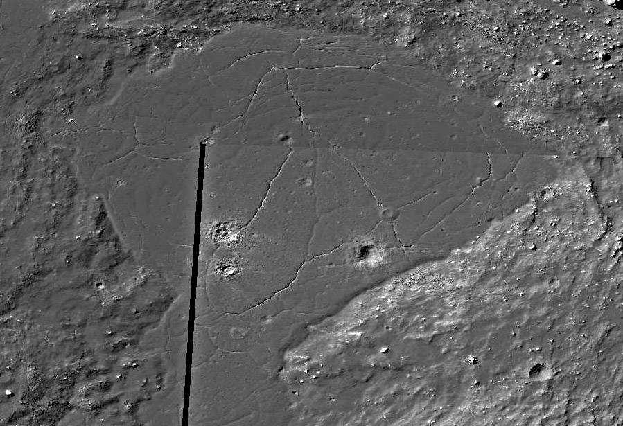
While researching yesterday's LPOD about the white ridge east of Tycho I noticed interesting features in the impact melt ponds just outside Tycho's eastern rim. This is an enhanced view of an about 3 km wide pond at the northeast end of the pond collection. Two things immediately caught my eye - the mostly concentric pattern of cracks, and the little elevated cones above the blocky impact crater at right center. The cracks are just that, not rilles due to the flow of melted material. I wondered why they were roughly concentric until I made a topography trace across the pond. I was astonished. I had always thought that because impact melt was liquid that ponds would have level surfaces, but that is not true. This one is about 45 m deeper in the center than around opposite edges (depths vary in different directions), so the cracks are where the solid surfaces fractured as the center subsided. Look closer and notice across the top of the pond that there are parallel low ridges where the plastic surface folded as the liquid parts below continued to move. The cracks cut the folds and thus formed later. Return now to the elevated crater. I doubt if that is a modified impact crater; its location at a crossing point of cracks suggests that it formed of still liquid melt from below that was pressured up the crack intersection. Perhaps the rising melt was somewhat cooled and thus more viscous, and only flowed a short distance in all directions. This happens at terrestrial lava flows, building small cones called rootless vents because there is no conduit bringing molten material from great depth; here is an example from Hawaii. Another possible such cone is near the bottom center of the image. Look around at the other ponds, especially this nearby area where one pond overflowed along a low spot, sending a narrow flow of impact melt downslope, feeding a lower elevation depression. This lower pond has a beautifully crumpled surface where the pressure from the flowing melt folded slower moving parts in front of it. You can sometimes see exactly this sort of feature during eruptions in Hawaii.
Chuck Wood
Yesterday's LPOD: A Lunar King
Tomorrow's LPOD: Perfect Morning for a New Day
COMMENTS?
Register, Log in, and join in the comments.


