Difference between revisions of "December 13, 2009"
| Line 1: | Line 1: | ||
__NOTOC__ | __NOTOC__ | ||
=Geo Textbook= | =Geo Textbook= | ||
| + | <!-- Start of content --> | ||
<!-- ws:start:WikiTextHeadingRule:1:<h1> --> | <!-- ws:start:WikiTextHeadingRule:1:<h1> --> | ||
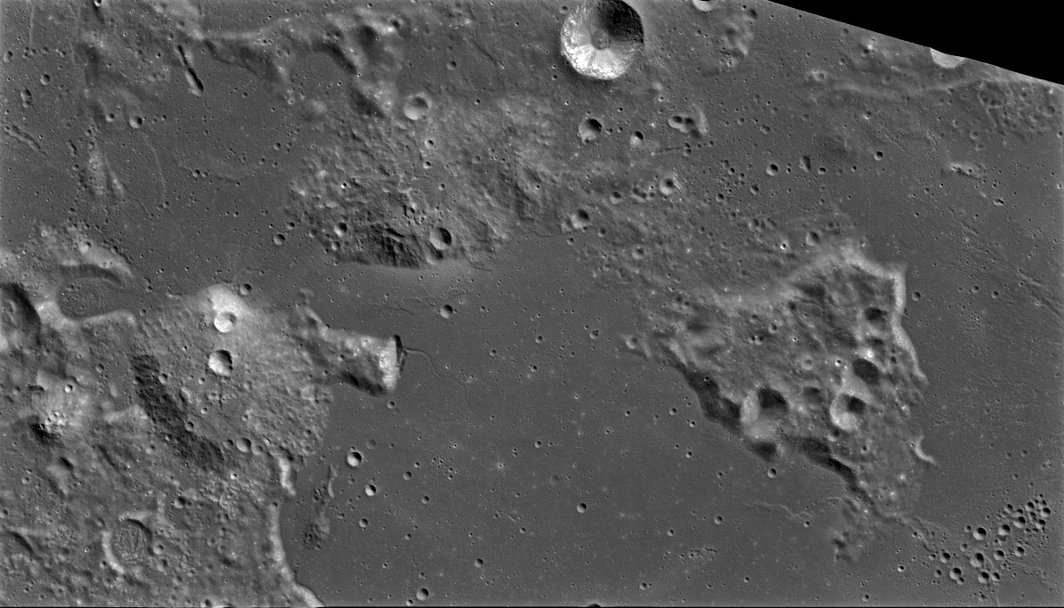
<!-- ws:start:WikiTextLocalImageRule:27:<img src="/file/view/LPOD-Dec13-09.jpg/109130933/LPOD-Dec13-09.jpg" alt="" title="" /> -->[[File:LPOD-Dec13-09.jpg|LPOD-Dec13-09.jpg]]<!-- ws:end:WikiTextLocalImageRule:27 --><br /> | <!-- ws:start:WikiTextLocalImageRule:27:<img src="/file/view/LPOD-Dec13-09.jpg/109130933/LPOD-Dec13-09.jpg" alt="" title="" /> -->[[File:LPOD-Dec13-09.jpg|LPOD-Dec13-09.jpg]]<!-- ws:end:WikiTextLocalImageRule:27 --><br /> | ||
<em>image from [http://wms.selene.jaxa.jp/selene_viewer/jpn/observation_mission/tc/tc_053.html Kaguya Image Gallery], copyright JAXA/Selene (north to upper left)</em><br /> | <em>image from [http://wms.selene.jaxa.jp/selene_viewer/jpn/observation_mission/tc/tc_053.html Kaguya Image Gallery], copyright JAXA/Selene (north to upper left)</em><br /> | ||
| + | <table class="wiki_table"> | ||
| + | <tr> | ||
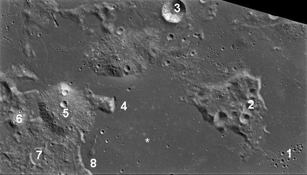
| + | <td><!-- ws:start:WikiTextLocalImageRule:28:<img src="/file/view/LPOD-Dec13-09b.jpg/109132429/LPOD-Dec13-09b.jpg" alt="" title="" /> -->[[File:LPOD-Dec13-09b.jpg|LPOD-Dec13-09b.jpg]]<!-- ws:end:WikiTextLocalImageRule:28 --><br /> | ||
| + | </td> | ||
| + | <td>I see about eight major insights and lessons in this wonderful, newly released Kaguya Terrain Camera image. (1) At bottom right is a tight cluster of secondary craters. They mostly do not overlap and each looks remarkably like a primary impact - only by seeing the cluster do we know that they must have formed from a slightly disaggregated clump of debris. How many secondaries do we mistake for primaries? (2) This overlapping chain of four older craters have straight septa between them, a sure sign of simultaneous, presumably secondary, origin. (1) and (2) demonstrate that secondaries can be decidely different in morphology. (3) This simple impact crater (Gruithuisen B) is 9 km wide. Already the transition to complex crater morphology has begun, as demonstrated by the tiny central peak. We used to think that peaks<br /> | ||
| + | </td> | ||
| + | </tr> | ||
| + | <tr> | ||
| + | <td>appeared at crater diameters of 10-15 km, but better resolution may show they commonly exist in smaller craters. (4) We need a name for sinuous rilles that start in elongate depressions, which like this one, often are along the edges of mountains. If you download this image and enhance it intensely you will see that the rille goes as far as the asterisk. Rilles may have emplaced most mare lavas, but many are too narrow or too eroded to be easily detected. (5) The Gruithuisen Domes are the most famous atypical domes. Their spectral reflectivities show they aren't normal mare basalts, as do their morphologies. Most domes have very low slopes that feather into the surrounding lavas. This high resolution view shows that there are changes in slope as the rounded summit gives way to steeper edges. (6) This little dome was previously recognized as similar to the larger Gruithuisen Domes, but never before could we see the shape so well. The steep edges and summit pierced by peaks is exactly like many viscous lava [http://en.wikipedia.org/wiki/Lava_dome domes] on Earth. (7) The floor of this subdued crater is full of rounded hills and crude crevices. This is similar to what some lunar mappers once called turtleback crater floors, speculating that they resulted from cooling and cracking of partially molten fill. (8) Rilles like to hug edges of mountains - why? Hadley Rille does for a while, as does a rille in Posidonius. Again, why? There are more things to notice in the image - for example, do you see the boundary between younger and older lava in the strait east of (5)?<br /> | ||
| + | <br /> | ||
| + | <em>[mailto:tychocrater@yahoo.com Chuck Wood]</em><br /> | ||
| + | <br /> | ||
| + | <strong>Related Links</strong><br /> | ||
| + | Rükl plate [http://the-moon.wikispaces.com/R%C3%BCkl+9 9]<br /> | ||
<br /> | <br /> | ||
| − | |||
| − | |||
<hr /> | <hr /> | ||
<br /> | <br /> | ||
<!-- Removed reference to store page --> | <!-- Removed reference to store page --> | ||
| + | <p><b>Yesterday's LPOD:</b> [[December 12, 2009|Planning a Lunar Christmas]] </p> | ||
| + | <p><b>Tomorrow's LPOD:</b> [[December 14, 2009|Brittannia]] </p> | ||
| + | <!-- End of content --> | ||
{{wiki/ArticleFooter}} | {{wiki/ArticleFooter}} | ||
Revision as of 21:55, 7 February 2015
Geo Textbook

image from Kaguya Image Gallery, copyright JAXA/Selene (north to upper left)
 |
I see about eight major insights and lessons in this wonderful, newly released Kaguya Terrain Camera image. (1) At bottom right is a tight cluster of secondary craters. They mostly do not overlap and each looks remarkably like a primary impact - only by seeing the cluster do we know that they must have formed from a slightly disaggregated clump of debris. How many secondaries do we mistake for primaries? (2) This overlapping chain of four older craters have straight septa between them, a sure sign of simultaneous, presumably secondary, origin. (1) and (2) demonstrate that secondaries can be decidely different in morphology. (3) This simple impact crater (Gruithuisen B) is 9 km wide. Already the transition to complex crater morphology has begun, as demonstrated by the tiny central peak. We used to think that peaks |
| appeared at crater diameters of 10-15 km, but better resolution may show they commonly exist in smaller craters. (4) We need a name for sinuous rilles that start in elongate depressions, which like this one, often are along the edges of mountains. If you download this image and enhance it intensely you will see that the rille goes as far as the asterisk. Rilles may have emplaced most mare lavas, but many are too narrow or too eroded to be easily detected. (5) The Gruithuisen Domes are the most famous atypical domes. Their spectral reflectivities show they aren't normal mare basalts, as do their morphologies. Most domes have very low slopes that feather into the surrounding lavas. This high resolution view shows that there are changes in slope as the rounded summit gives way to steeper edges. (6) This little dome was previously recognized as similar to the larger Gruithuisen Domes, but never before could we see the shape so well. The steep edges and summit pierced by peaks is exactly like many viscous lava domes on Earth. (7) The floor of this subdued crater is full of rounded hills and crude crevices. This is similar to what some lunar mappers once called turtleback crater floors, speculating that they resulted from cooling and cracking of partially molten fill. (8) Rilles like to hug edges of mountains - why? Hadley Rille does for a while, as does a rille in Posidonius. Again, why? There are more things to notice in the image - for example, do you see the boundary between younger and older lava in the strait east of (5)?
Yesterday's LPOD: Planning a Lunar Christmas Tomorrow's LPOD: Brittannia COMMENTS?Register, Log in, and join in the comments.
|


