March 22, 2008
Another Megadome

image from the Kaguya Image Gallery (c) JAXA/SELENE
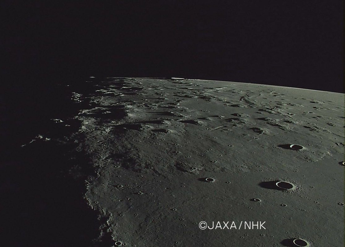
The Marius Hills have a variety of components, included domes, steep sided hills and sinuous rilles. Amateur images also have depicted what looks like a lava flow front or large rough dome along the northern edge of the Hills, and this Kaguya HDTV image, taken as the spacecraft flew northward, beautifully reveals it. The edge of the flow/dome is higher and the surface rougher than both the mare in the foreground and the smooth lava between domes in the top half of the image. This North Marius Megadome tapers toward the mare, just as expected if were emplaced as a lava flow. Three shadow-casting hills near the summit of the megadome could be at its vent, but the other steep hills aren't sources of similar rough flows so the connection is unclear. This marvelous image is a complement to the ancient Lunar Orbiter II image which was taken from the south, looking north.
Chuck Wood
Related Links
Rükl plate 18
Yesterday's LPOD: A Global Eclipse
Tomorrow's LPOD: Skinny Moon
COMMENTS
(1) I wonder why this image looks so dark? Was it taken with a filter of some kind?
--Bill
(2) Thanks for sharing this wonderful Kaguya image. I'm never quite sure what they've released. With my dial-up connection it takes 4-5 minutes to get past the "Welcome" screen of the Kaguya Image Gallery, and another 4 minutes or so clicking the "Next" button in the HDTV Gallery to determine that "Around Marius Hills" (on page "5/7") was taken at some unknown hour on January 5, 2008 (JST) and that there is no "Image with captions". Not to complain, but since we're supposed to concerned about conserving the world's resources (including, I suppose internet bandwidth), is it really necessary to ship multiple megabytes of largely irrelevant data from Japan to California to answer so simple an inquiry with so minimal a response?
Also, although the Kaguya HDTV experiment is primarily for promotional purposes, it looks like it returns useful scientific results as well -- in addition to your geological interpretation, the broad perspective of precise shadow lengths this image provides could certainly be used as a helpful cross-check on the topographic results to be obtained with the other instruments. I presume the Kaguya scientists must know exactly where the HDTV camera was located when this photo was taken (spacecraft longitude, latitude, elevation and universal time). Would it really require a lot of additional effort, or be "tipping their hand," to put that information in the caption?
That said, the Moon was a waning crescent on Jan 5th, so the image must, as your description implies, have been taken looking south. How it can be determined from this photo alone that the spacecraft was flying northward is less clear to me -- presumably that's evident from the full video, which is perhaps available somewhere else in the Image Gallery?
Judging from the terminator position on the wrinkle ridge in the lower left it may have been taken around 01 UT on Jan 5 (10 am JST?). The foreground craters are evidently Marius N, M and L with a tiny bit of Marius Q along the right margin, and a fragment of Rima Marius on the left. This region was previously imaged obliquely from the north (with opposite lighting) by the Metric Camera on Apollo 15 (series of frames around AS15-M-2612, where it is quite close to the horizon). Arizona State University should soon be releasing high resolution scans of those (as of March 1 they were up to AS15-M-2173).
Since we are so accustomed to looking at overhead views, readers may enjoy comparing this to the high resolution scans of Lunar Orbiter IV-157H. The arrowhead shaped depression near the middle of the Kaguya image (54.6W/15.0N on the Moon) is easy to spot in both. From there one can work over to the three peaks atop the flow (which, to me, look similar to most other peaks in the area). And working in the other direction, try to locate the famous (but unnamed) sperm-looking rilles to the SW of the arrowhead in the Kaguya image. With the Lunar Orbiter "map" as a guide, it's not hard to find them in the HDTV shot, but I don't think I would have known what they were. Rima Galilaei is out there too. Finally, working south from the arrowhead, one can see where the bright dustings of Reiner Gamma should be (did the spacecraft pass over them a little earlier?), and try to guess what that bright streak on the southern limb is. It must be much more clear from the video, but I'm assuming it's Reiner, casting its sunset shadow to the left, with maybe little Reiner L (highly foreshortened) on its flank?
The difference in appearances looking vertically versus from an oblique angle is certainly striking here!
-- Jim
(3) Bill and Jim
The HDTV has, I believe, and automatic light meter adjustment - it must have thought this was the right exposure, and it looks good on my laptop.
The Kaguya website is designed for artistic sensibility rather than effectiveness. For example, I saw this video at Houston - that is why I know the space craft was flying N to S, but it is too difficult to find it on the Kaguya video page - I wish they would provide a few words of areas depicted on each video!
I tried to stress in a previous LPOD and to Kaguya folks that there is great scientific value in the HDTV images. I hope they are ultimately made available for full study.
Chuck
COMMENTS?
Register, Log in, and join in the comments.


