Difference between revisions of "April 22, 2010"
| Line 1: | Line 1: | ||
__NOTOC__ | __NOTOC__ | ||
=Colorful Pits= | =Colorful Pits= | ||
| − | |||
<!-- ws:start:WikiTextHeadingRule:1:<h1> --> | <!-- ws:start:WikiTextHeadingRule:1:<h1> --> | ||
<!-- ws:start:WikiTextLocalImageRule:16:<img src="/file/view/LPOD-Apr-22-10.jpg/136219435/LPOD-Apr-22-10.jpg" alt="" title="" /> -->[[File:LPOD-Apr-22-10.jpg|LPOD-Apr-22-10.jpg]]<!-- ws:end:WikiTextLocalImageRule:16 --><br /> | <!-- ws:start:WikiTextLocalImageRule:16:<img src="/file/view/LPOD-Apr-22-10.jpg/136219435/LPOD-Apr-22-10.jpg" alt="" title="" /> -->[[File:LPOD-Apr-22-10.jpg|LPOD-Apr-22-10.jpg]]<!-- ws:end:WikiTextLocalImageRule:16 --><br /> | ||
| − | <em>south up image by [mailto:mauricejscollins@hotmail.com Maurice Collins], Palmerston North, New Zealand</em><br /> | + | <em>south up image by [mailto:mauricejscollins@hotmail.com" rel="nofollow Maurice Collins], Palmerston North, New Zealand</em><br /> |
<br /> | <br /> | ||
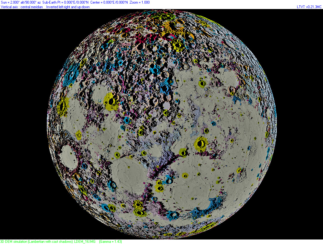
| − | A few days [ | + | A few days [/April+18%2C+2010 ago] when I saw Maurice's draping of the old (but only one that exists) USGS geologic map of the Moon over a digital terrain map created with Jim Mosher's LTVT using the LRO laser altimetry data, I realized how helpful combining data sets can be in understanding our satellite. But I noticed that away from the terminator the DTM accurately showed no shadows and hence it was hard to compare geology with topography. I asked Maurice if it would be possible to use LTVT to depict the DTM with a constant Sun angle across the Moon. Jim [http://ltvt.wikispaces.com/Special+Version+-+Constant+Illumination modified] LTVT for Maurice to do that and, presto, we have the lunar nearside geology superposed on a topo map with 2° illumination everywhere. The highlands are very reminiscent of the old [http://atschool.eduweb.co.uk/bookman/library/THEMOON/INDEX.HTM" rel="nofollow Nasmyth] plaster [http://atschool.eduweb.co.uk/bookman/library/THEMOON/PLATE20.JPG" rel="nofollow models] that exaggerated the relief of craters. But this is the actual, but impossible, way the Moon would look if everywhere could instantaneously be illuminated with a low Sun. The yellow and green colors indicate the post-mare craters, and clearly they are not evenly distributed across the nearside; the only large ones in the upper-right quadrant are Tycho and Bullialdus. The map also shows two long ridges defined by shadows - they cross just above and to the left of Eudoxus. Are they real or eye-fooling imaginary lines?<br /> |
<br /> | <br /> | ||
| − | <em>[mailto:tychocrater@yahoo.com Chuck Wood]</em><br /> | + | <em>[mailto:tychocrater@yahoo.com" rel="nofollow Chuck Wood]</em><br /> |
<br /> | <br /> | ||
<strong>Related Links</strong><br /> | <strong>Related Links</strong><br /> | ||
| − | Maurice's [http://moonscience.yolasite.com/ website]<br /> | + | Maurice's [http://moonscience.yolasite.com/" rel="nofollow website]<br /> |
<br /> | <br /> | ||
<hr /> | <hr /> | ||
| − | <div>You can support LPOD when you buy any book from Amazon thru [http://www.lpod.org/?page_id=591 LPOD!]<br /> | + | <div>You can support LPOD when you buy any book from Amazon thru [http://www.lpod.org/?page_id=591" rel="nofollow LPOD!]<br /> |
</div> | </div> | ||
| − | |||
---- | ---- | ||
===COMMENTS?=== | ===COMMENTS?=== | ||
Click on this icon [[image:PostIcon.jpg]] at the upper right to post a comment. | Click on this icon [[image:PostIcon.jpg]] at the upper right to post a comment. | ||
Revision as of 19:22, 4 January 2015
Colorful Pits

south up image by " rel="nofollow Maurice Collins, Palmerston North, New Zealand
A few days [/April+18%2C+2010 ago] when I saw Maurice's draping of the old (but only one that exists) USGS geologic map of the Moon over a digital terrain map created with Jim Mosher's LTVT using the LRO laser altimetry data, I realized how helpful combining data sets can be in understanding our satellite. But I noticed that away from the terminator the DTM accurately showed no shadows and hence it was hard to compare geology with topography. I asked Maurice if it would be possible to use LTVT to depict the DTM with a constant Sun angle across the Moon. Jim modified LTVT for Maurice to do that and, presto, we have the lunar nearside geology superposed on a topo map with 2° illumination everywhere. The highlands are very reminiscent of the old " rel="nofollow Nasmyth plaster " rel="nofollow models that exaggerated the relief of craters. But this is the actual, but impossible, way the Moon would look if everywhere could instantaneously be illuminated with a low Sun. The yellow and green colors indicate the post-mare craters, and clearly they are not evenly distributed across the nearside; the only large ones in the upper-right quadrant are Tycho and Bullialdus. The map also shows two long ridges defined by shadows - they cross just above and to the left of Eudoxus. Are they real or eye-fooling imaginary lines?
" rel="nofollow Chuck Wood
Related Links
Maurice's " rel="nofollow website
COMMENTS?
Click on this icon File:PostIcon.jpg at the upper right to post a comment.


