Difference between revisions of "May 16, 2013"
| Line 1: | Line 1: | ||
__NOTOC__ | __NOTOC__ | ||
=Lonesome Chain= | =Lonesome Chain= | ||
| − | |||
<!-- ws:start:WikiTextHeadingRule:0:<h1> --> | <!-- ws:start:WikiTextHeadingRule:0:<h1> --> | ||
<!-- ws:start:WikiTextLocalImageRule:14:<img src="/file/view/LPOD-May16-13.jpg/431945532/LPOD-May16-13.jpg" alt="" title="" /> -->[[File:LPOD-May16-13.jpg|LPOD-May16-13.jpg]]<!-- ws:end:WikiTextLocalImageRule:14 --><br /> | <!-- ws:start:WikiTextLocalImageRule:14:<img src="/file/view/LPOD-May16-13.jpg/431945532/LPOD-May16-13.jpg" alt="" title="" /> -->[[File:LPOD-May16-13.jpg|LPOD-May16-13.jpg]]<!-- ws:end:WikiTextLocalImageRule:14 --><br /> | ||
| − | <em>approximate north up image by [mailto:mwirths@superaje.com Mike Wirths], Baja California, Mexico</em><br /> | + | <em>approximate north up image by [mailto:mwirths@superaje.com" rel="nofollow Mike Wirths], Baja California, Mexico</em><br /> |
<br /> | <br /> | ||
<table class="wiki_table"> | <table class="wiki_table"> | ||
| Line 10: | Line 9: | ||
<td><!-- ws:start:WikiTextLocalImageRule:15:<img src="/file/view/LPOD-May16-13b.jpg/431945594/LPOD-May16-13b.jpg" alt="" title="" /> -->[[File:LPOD-May16-13b.jpg|LPOD-May16-13b.jpg]]<!-- ws:end:WikiTextLocalImageRule:15 --><br /> | <td><!-- ws:start:WikiTextLocalImageRule:15:<img src="/file/view/LPOD-May16-13b.jpg/431945594/LPOD-May16-13b.jpg" alt="" title="" /> -->[[File:LPOD-May16-13b.jpg|LPOD-May16-13b.jpg]]<!-- ws:end:WikiTextLocalImageRule:15 --><br /> | ||
</td> | </td> | ||
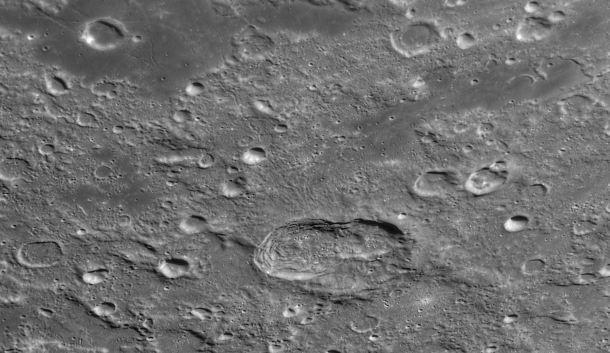
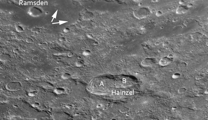
| − | <td>Hainzel A and B were probably formed by the simultaneous impact of a split comet or asteroid. Hainzel may have been a pre-existing older crater or perhaps was formed slightly earlier as part of the A/B collisions. What is remarkable is the very asymmetric distribution of ejecta. There is very little in any direction except to the north towards Ramsden. A broad swath of radial ridges and gullies extend from A about 30 km. Beyond that a single squiggly chain of secondaries goes 150 km from the crater rim to the edge of the mare. The chain extends another 35-40 km across the mare with a surrounding pin-pricks of brightness. The LRO QuickMap [http://target.lroc.asu.edu/da/qmap.html?mv=eqc&mcx=-933586.33233&mcy=-1045338.80016&mz=8 shows] this extension across the mare to be a classic herringbone secondary chain with slightly overlapping craters wrapped in ejecta, making a v-pattern. This entire 190 km long chain is radial to the intersection of A and B, rather than the center of A. This seems to be strong evidence that A and B did form simultaneously. I can't see evidence of the herringbone pattern anywhere along the chain except where it cuts the mare. Perhaps the highland terrain is too rough for it to form.<br /> | + | <td>Hainzel A and B were probably formed by the simultaneous impact of a split comet or asteroid. Hainzel may have been a pre-existing older crater or perhaps was formed slightly earlier as part of the A/B collisions. What is remarkable is the very asymmetric distribution of ejecta. There is very little in any direction except to the north towards Ramsden. A broad swath of radial ridges and gullies extend from A about 30 km. Beyond that a single squiggly chain of secondaries goes 150 km from the crater rim to the edge of the mare. The chain extends another 35-40 km across the mare with a surrounding pin-pricks of brightness. The LRO QuickMap [http://target.lroc.asu.edu/da/qmap.html?mv=eqc&mcx=-933586.33233&mcy=-1045338.80016&mz=8" rel="nofollow shows] this extension across the mare to be a classic herringbone secondary chain with slightly overlapping craters wrapped in ejecta, making a v-pattern. This entire 190 km long chain is radial to the intersection of A and B, rather than the center of A. This seems to be strong evidence that A and B did form simultaneously. I can't see evidence of the herringbone pattern anywhere along the chain except where it cuts the mare. Perhaps the highland terrain is too rough for it to form.<br /> |
<br /> | <br /> | ||
| − | <em>[mailto:tychocrater@yahoo.com Chuck Wood]</em><br /> | + | <em>[mailto:tychocrater@yahoo.com" rel="nofollow Chuck Wood]</em><br /> |
<br /> | <br /> | ||
<strong>Technical Details</strong><br /> | <strong>Technical Details</strong><br /> | ||
Revision as of 22:45, 4 January 2015
Lonesome Chain

approximate north up image by " rel="nofollow Mike Wirths, Baja California, Mexico
 |
Hainzel A and B were probably formed by the simultaneous impact of a split comet or asteroid. Hainzel may have been a pre-existing older crater or perhaps was formed slightly earlier as part of the A/B collisions. What is remarkable is the very asymmetric distribution of ejecta. There is very little in any direction except to the north towards Ramsden. A broad swath of radial ridges and gullies extend from A about 30 km. Beyond that a single squiggly chain of secondaries goes 150 km from the crater rim to the edge of the mare. The chain extends another 35-40 km across the mare with a surrounding pin-pricks of brightness. The LRO QuickMap " rel="nofollow shows this extension across the mare to be a classic herringbone secondary chain with slightly overlapping craters wrapped in ejecta, making a v-pattern. This entire 190 km long chain is radial to the intersection of A and B, rather than the center of A. This seems to be strong evidence that A and B did form simultaneously. I can't see evidence of the herringbone pattern anywhere along the chain except where it cuts the mare. Perhaps the highland terrain is too rough for it to form.
|


