August 20, 2012
Wow!

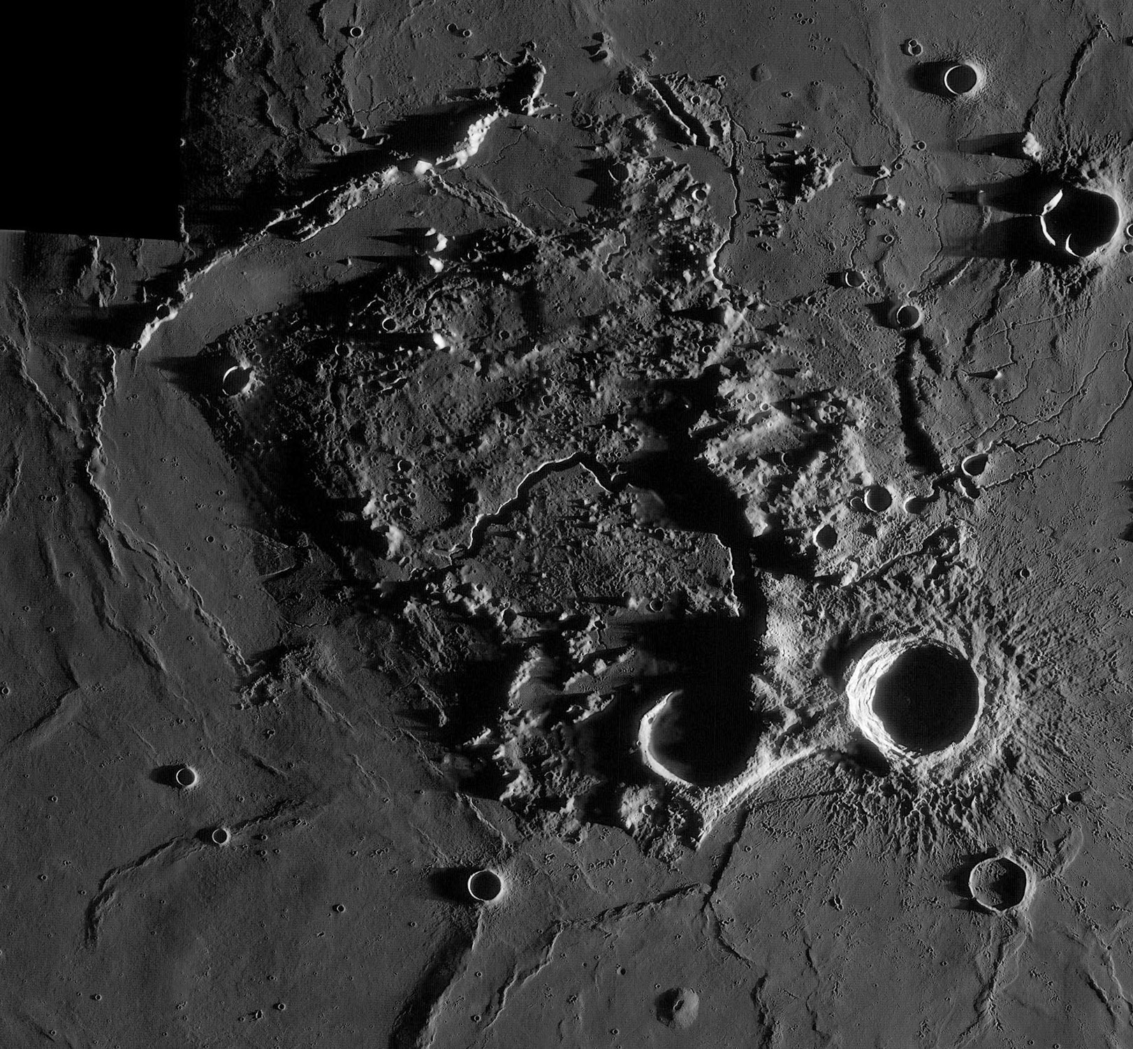
LRO WAC mosaic processed by Maurice Collins, New Zealand
The normal 100 m resolution LRO Wide Angle Camera (WAC) mosaics are wonderful, but Maurice's mosaic of the Aristarchus Plateau using low Sun WAC files is phenomenal. This full resolution image is simply beautiful, and it shows this unique landform in a powerful new way. I can imagine someone doing a doctoral thesis on the origin and structure of the Plateau with this a primary data source, and inspiration. Here are a few observations.
- First, Schröter's Valley begins in a pit (here shadowed) called the Cobra's Head. It is less well known that the pit is on the side of a substantial mountain, here dramatically indicated by a 50 km long shadow. Altimetry measurements from LRO QuickMap show that the mountain, which I now call Cobra Mountain, is 40 km wide and 2 km high. This is almost certainly a volcanic peak, made up of pyroclastics and/or lava flows from the Cobra Head vent or its predecessor.
- A second observation concerns the entire Plateau. The areas east and north of Schröter's Valley are crossed by ridges that are parallel with the northern edge of the Plateau and the thin chain of the Agricola Mountains. Perhaps these are structural features relating to the Plateau's origin. I had always imagined the Aristarchus Plateau as being intimately related to the Imbrium Basin, but these ridges aren't radial to that basin but they are, more or less, to the Orientale Basin. It is hard to imagine how Orientale could cause the formation of the Plateau.
- Here is a third observation. About halfway along the western edge of the Plateau is a bow of material sticking further out into the mare than the rest of that margin. Is this a delta of the last lava deposited by Schröter's Valley? And what happens to the main 5 km wide valley at its western end? The small inner rille breaks through the valley wall where the valley bend to the north and then stops. This low lighting suggests the valley continued a short distance up to the east of the bright peak. The delta is also cut by a 5 km wide flat-floor trough that looks like the valley. Is it or is it the vent area for a rille now covered by Procellarum lavas?
- Finally, look at the well known fault scarp just south of Herodotus. This 110 m high, west-facing scarp is seen here at its north end to bend abruptly toward the east and continue through ejecta from Aristarchus. This scarp is also a maximum of 110 m high, but it is completely invisible in the higher Sun QuickMap image. I am thankful for this MPOD - Maurice Image of the Day.
Chuck Wood
Technical Details
Maurice has put together a number of mosaics of different areas from low Sun WAC images. The fact that there are so many WACs with similar illumination must mean that the LRO team is acquiring them systematically. I look forward to the day when they amaze the world with a global mosaic that looks like this piece of the Aristarchus Plateau.
Related Links
Rükl plate 18
Yesterday's LPOD: Small Mystery
Tomorrow's LPOD: Linears
COMMENTS?
Register, Log in, and join in the comments.


