March 19, 2023
Remembrance of Basins Past
Originally published April 25, 2013

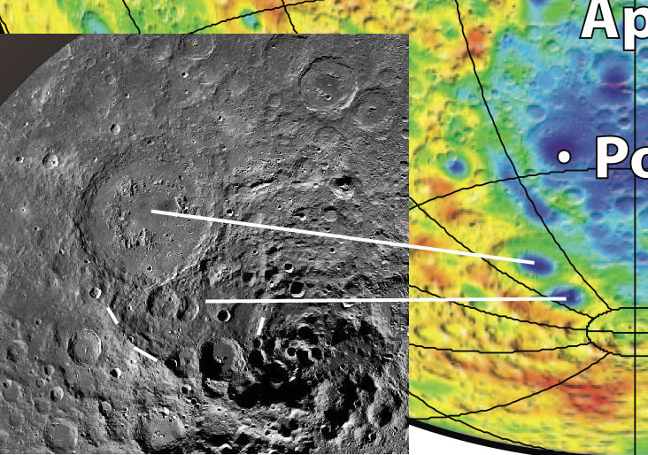
left image from LRO QuickMap and right from Crustal Thickness Map.
Once the first images of the lunar south polar region became available the magnificent Schrödinger Basin dominated our interest. But once we looked further around another possible old basin was noticed. The three short white lines mark the proposed southern rim of the proposed Ancient Schrödinger Basin (ASB). The northern portion of this ancient basin was apparently destroyed by the formation of its namesake. The possible rim is suggestive but not convincing, the ridges might just be remnants of old craters that are otherwise gone. Who knows? But the recently released crustal thickness map based on GRAIL gravity data and LRO topography provides convincing evidence that, yes, ASB is real. The two long white lines tie together the same points on the LRO image (left) and the crustal thickness map (right). The blue oval shows that the young Schrödinger Basin has a thinned crust inside the inner rim. And the ASB does too, in fact, the purple indicates that the crust is even thinner, less than 5 km thick. Interestingly, the floor of the nearby fresh crater Amundsen is 500 m deeper than the lowest point in ASB; it may have excavated a near surface pluton or the lunar mantle. You can't be expected to understand the Moon with just one data set.
Chuck Wood
Related Links
21st Century Atlas chart L4.
Yesterday's LPOD: A Dome of a Different Color
Tomorrow's LPOD: Smudge of an Eclipse
COMMENTS?
Register, Log in, and join in the comments.


