Difference between revisions of "May 26, 2013"
| Line 1: | Line 1: | ||
__NOTOC__ | __NOTOC__ | ||
=New Light On the Basin Near Schiller= | =New Light On the Basin Near Schiller= | ||
| − | |||
<!-- ws:start:WikiTextHeadingRule:0:<h1> --> | <!-- ws:start:WikiTextHeadingRule:0:<h1> --> | ||
<!-- ws:start:WikiTextLocalImageRule:14:<img src="/file/view/LPOD-Dec5-10.jpg/185261299/LPOD-Dec5-10.jpg" alt="" title="" /> -->[[File:LPOD-Dec5-10.jpg|LPOD-Dec5-10.jpg]]<!-- ws:end:WikiTextLocalImageRule:14 --><br /> | <!-- ws:start:WikiTextLocalImageRule:14:<img src="/file/view/LPOD-Dec5-10.jpg/185261299/LPOD-Dec5-10.jpg" alt="" title="" /> -->[[File:LPOD-Dec5-10.jpg|LPOD-Dec5-10.jpg]]<!-- ws:end:WikiTextLocalImageRule:14 --><br /> | ||
| − | <em>LRO DEM image by [mailto:mauricejscollins@hotmail.com Maurice Collins], Palmerston North, New Zealand</em><br /> | + | <em>LRO DEM image by [mailto:mauricejscollins@hotmail.com" rel="nofollow Maurice Collins], Palmerston North, New Zealand</em><br /> |
<br /> | <br /> | ||
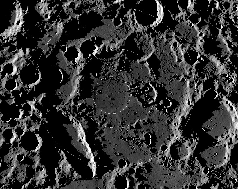
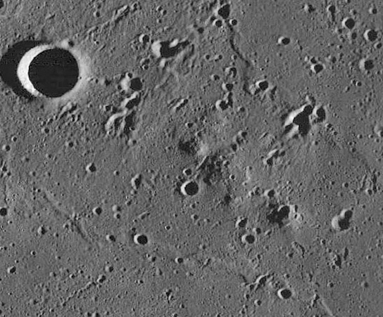
| − | When Bill Hartmann and Gerard Kuiper first [http://www.lpl.arizona.edu/SIC/journal/pdfs/012_Hartmann_CommLPL_1962.pdf described] this overlooked basin near Schiller, they gave it that prosaic name. Later the US Geological Survey Moon mappers initiated a system of calling basins by craters on opposite sides and this feature became known as the Schiller-Zucchius Basin. It differs from most of the more familiar nearside basins in having a mountainous inner ring (where it is preserved) and at first glance seems to be a two-ring basin. <em>Seems to be</em> implies it isn't and that is probably true, but maybe not. There is an inner depression that is marked by ghost crater-like gentle ridges - a possible third ring - but it is decidedly off-center from the other two rings, and could be a random impact that occurred and was later buried when the basin was flooded by lava. Not all basin rings are perfectly concentric so this could be a three-ring basin. When Maurice processed this digital terrain image he noticed the line of small hills near the middle of the inner ghost ring. He found them on a LRO Wide Angle Camera frame and commented, correctly, that they looked like the rough-textured Marius Hills domes. It is not surprising the find volcanic cones - if that is what they are - in the center of a widespread sea of mare lavas, but most maria show little evidence of the vents that may have fed them. <br /> | + | When Bill Hartmann and Gerard Kuiper first [http://www.lpl.arizona.edu/SIC/journal/pdfs/012_Hartmann_CommLPL_1962.pdf" rel="nofollow described] this overlooked basin near Schiller, they gave it that prosaic name. Later the US Geological Survey Moon mappers initiated a system of calling basins by craters on opposite sides and this feature became known as the Schiller-Zucchius Basin. It differs from most of the more familiar nearside basins in having a mountainous inner ring (where it is preserved) and at first glance seems to be a two-ring basin. <em>Seems to be</em> implies it isn't and that is probably true, but maybe not. There is an inner depression that is marked by ghost crater-like gentle ridges - a possible third ring - but it is decidedly off-center from the other two rings, and could be a random impact that occurred and was later buried when the basin was flooded by lava. Not all basin rings are perfectly concentric so this could be a three-ring basin. When Maurice processed this digital terrain image he noticed the line of small hills near the middle of the inner ghost ring. He found them on a LRO Wide Angle Camera frame and commented, correctly, that they looked like the rough-textured Marius Hills domes. It is not surprising the find volcanic cones - if that is what they are - in the center of a widespread sea of mare lavas, but most maria show little evidence of the vents that may have fed them. <br /> |
<table class="wiki_table"> | <table class="wiki_table"> | ||
<tr> | <tr> | ||
<td><!-- ws:start:WikiTextLocalImageRule:15:<img src="/file/view/LPOD-Dec5-10b.jpg/185265445/LPOD-Dec5-10b.jpg" alt="" title="" /> -->[[File:LPOD-Dec5-10b.jpg|LPOD-Dec5-10b.jpg]]<!-- ws:end:WikiTextLocalImageRule:15 --><br /> | <td><!-- ws:start:WikiTextLocalImageRule:15:<img src="/file/view/LPOD-Dec5-10b.jpg/185265445/LPOD-Dec5-10b.jpg" alt="" title="" /> -->[[File:LPOD-Dec5-10b.jpg|LPOD-Dec5-10b.jpg]]<!-- ws:end:WikiTextLocalImageRule:15 --><br /> | ||
</td> | </td> | ||
| − | <td><em>[mailto:tychocrater@yahoo.com Chuck Wood]</em><br /> | + | <td><em>[mailto:tychocrater@yahoo.com" rel="nofollow Chuck Wood]</em><br /> |
(This is a classic LPOD from [http://lpod.wikispaces.com/December+5%2C+2010 Dec 5, 2010].)<br /> | (This is a classic LPOD from [http://lpod.wikispaces.com/December+5%2C+2010 Dec 5, 2010].)<br /> | ||
<br /> | <br /> | ||
| Line 20: | Line 19: | ||
Rükl plate [http://the-moon.wikispaces.com/R%C3%BCkl+71 71]<br /> | Rükl plate [http://the-moon.wikispaces.com/R%C3%BCkl+71 71]<br /> | ||
<em>[http://lpod.wikispaces.com/21st+Century+Atlas+of+the+Moon 21st Century Atlas]</em> chart 24 & B8.<br /> | <em>[http://lpod.wikispaces.com/21st+Century+Atlas+of+the+Moon 21st Century Atlas]</em> chart 24 & B8.<br /> | ||
| − | Maurice's Moon Science [http://moonscience.yolasite.com/ website]<br /> | + | Maurice's Moon Science [http://moonscience.yolasite.com/" rel="nofollow website]<br /> |
</td> | </td> | ||
</tr> | </tr> | ||
Revision as of 22:45, 4 January 2015
New Light On the Basin Near Schiller

LRO DEM image by " rel="nofollow Maurice Collins, Palmerston North, New Zealand
When Bill Hartmann and Gerard Kuiper first " rel="nofollow described this overlooked basin near Schiller, they gave it that prosaic name. Later the US Geological Survey Moon mappers initiated a system of calling basins by craters on opposite sides and this feature became known as the Schiller-Zucchius Basin. It differs from most of the more familiar nearside basins in having a mountainous inner ring (where it is preserved) and at first glance seems to be a two-ring basin. Seems to be implies it isn't and that is probably true, but maybe not. There is an inner depression that is marked by ghost crater-like gentle ridges - a possible third ring - but it is decidedly off-center from the other two rings, and could be a random impact that occurred and was later buried when the basin was flooded by lava. Not all basin rings are perfectly concentric so this could be a three-ring basin. When Maurice processed this digital terrain image he noticed the line of small hills near the middle of the inner ghost ring. He found them on a LRO Wide Angle Camera frame and commented, correctly, that they looked like the rough-textured Marius Hills domes. It is not surprising the find volcanic cones - if that is what they are - in the center of a widespread sea of mare lavas, but most maria show little evidence of the vents that may have fed them.
 |
" rel="nofollow Chuck Wood (This is a classic LPOD from Dec 5, 2010.) |


