Difference between revisions of "April 23, 2013"
| Line 1: | Line 1: | ||
__NOTOC__ | __NOTOC__ | ||
=625 Mm= | =625 Mm= | ||
| − | |||
<!-- ws:start:WikiTextHeadingRule:0:<h1> --> | <!-- ws:start:WikiTextHeadingRule:0:<h1> --> | ||
<!-- ws:start:WikiTextLocalImageRule:6:<img src="http://lpod.wikispaces.com/file/view/LPOD-Apr23-13.jpg/425523236/LPOD-Apr23-13.jpg" alt="" title="" /> -->[[File:LPOD-Apr23-13.jpg|LPOD-Apr23-13.jpg]]<!-- ws:end:WikiTextLocalImageRule:6 --><br /> | <!-- ws:start:WikiTextLocalImageRule:6:<img src="http://lpod.wikispaces.com/file/view/LPOD-Apr23-13.jpg/425523236/LPOD-Apr23-13.jpg" alt="" title="" /> -->[[File:LPOD-Apr23-13.jpg|LPOD-Apr23-13.jpg]]<!-- ws:end:WikiTextLocalImageRule:6 --><br /> | ||
| − | <em>image by [mailto:luccat@sfr.fr Luc Cathala], Mazan in Vaucluse in France</em><br /> | + | <em>image by [mailto:luccat@sfr.fr" rel="nofollow Luc Cathala], Mazan in Vaucluse in France</em><br /> |
<br /> | <br /> | ||
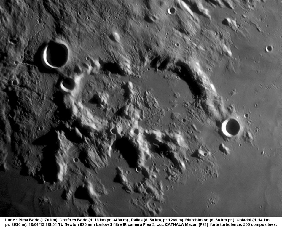
| − | Over the last decade we have seen that excellent craftsmanship can produce spectacular images from scopes of any size. And combining excellent technique with very large aperture, as Luc has done, creates memorable images. What is remarkable about this image is that this area was beautifully imaged [http://www.lpod.org/?m=20061102 previously] under opposite illumination. As described for that image, these craters, Pallas and Murchison, were lathered by pasty ejecta from the formation of the Imbrium Basin. Ground-hugging ejecta covered the terrain up to their rim crest and probably cascaded down onto the original crater floors. You can see it as a ring of debris around the central peak of Pallas and as hills on the floor of Murchison that stuck up above later lava flows. Flows of ejecta occur to the west of Pallas and another water-falled into Murchison. Sinuous rilles are prominent at upper right and upper left, and two short and flat-floored rille segments are visible at the 7 o'clock and 9 o'clock positions external to Pallas' rim.<br /> | + | Over the last decade we have seen that excellent craftsmanship can produce spectacular images from scopes of any size. And combining excellent technique with very large aperture, as Luc has done, creates memorable images. What is remarkable about this image is that this area was beautifully imaged [http://www.lpod.org/?m=20061102" rel="nofollow previously] under opposite illumination. As described for that image, these craters, Pallas and Murchison, were lathered by pasty ejecta from the formation of the Imbrium Basin. Ground-hugging ejecta covered the terrain up to their rim crest and probably cascaded down onto the original crater floors. You can see it as a ring of debris around the central peak of Pallas and as hills on the floor of Murchison that stuck up above later lava flows. Flows of ejecta occur to the west of Pallas and another water-falled into Murchison. Sinuous rilles are prominent at upper right and upper left, and two short and flat-floored rille segments are visible at the 7 o'clock and 9 o'clock positions external to Pallas' rim.<br /> |
<br /> | <br /> | ||
| − | <em>[mailto:tychocrater@yahoo.com Chuck Wood]</em><br /> | + | <em>[mailto:tychocrater@yahoo.com" rel="nofollow Chuck Wood]</em><br /> |
<br /> | <br /> | ||
<strong>Technical Details</strong><br /> | <strong>Technical Details</strong><br /> | ||
| Line 16: | Line 15: | ||
Rükl plate [http://the-moon.wikispaces.com/R%C3%BCkl+33 33]<br /> | Rükl plate [http://the-moon.wikispaces.com/R%C3%BCkl+33 33]<br /> | ||
<em>[http://lpod.wikispaces.com/21st+Century+Atlas+of+the+Moon 21st Century Atlas]</em> chart 17.<br /> | <em>[http://lpod.wikispaces.com/21st+Century+Atlas+of+the+Moon 21st Century Atlas]</em> chart 17.<br /> | ||
| − | Other [http://www.webastro.net/forum/showthread.php?t=105857 images] taken the same evening.<br /> | + | Other [http://www.webastro.net/forum/showthread.php?t=105857" rel="nofollow images] taken the same evening.<br /> |
<br /> | <br /> | ||
<hr /> | <hr /> | ||
Revision as of 22:44, 4 January 2015
625 Mm

image by " rel="nofollow Luc Cathala, Mazan in Vaucluse in France
Over the last decade we have seen that excellent craftsmanship can produce spectacular images from scopes of any size. And combining excellent technique with very large aperture, as Luc has done, creates memorable images. What is remarkable about this image is that this area was beautifully imaged " rel="nofollow previously under opposite illumination. As described for that image, these craters, Pallas and Murchison, were lathered by pasty ejecta from the formation of the Imbrium Basin. Ground-hugging ejecta covered the terrain up to their rim crest and probably cascaded down onto the original crater floors. You can see it as a ring of debris around the central peak of Pallas and as hills on the floor of Murchison that stuck up above later lava flows. Flows of ejecta occur to the west of Pallas and another water-falled into Murchison. Sinuous rilles are prominent at upper right and upper left, and two short and flat-floored rille segments are visible at the 7 o'clock and 9 o'clock positions external to Pallas' rim.
" rel="nofollow Chuck Wood
Technical Details
18/04/13 at 18h54 UT. 625 mm (diameter) F/D 4.37 newtonian telescope + barlow 2. Strong turbulence. Infra Red filter with a Point grey Flea 3 camera. 500 pictures stacked over 2200 with Autostackker 2 and treated by ondelettes with Registax 6.
Related Links
Rükl plate 33
21st Century Atlas chart 17.
Other " rel="nofollow images taken the same evening.


