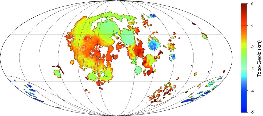
map from Mark Wieczorek
On Earth the oceans follow an equipotential surface or geoid. Sea level, in the absence of continents and winds, would be at nearly the same level everywhere. The map above shows the topography of the lunar maria, compared to the lunar geoid - which I suppose should really be called the lunoid. The highest places in the maria, compared to the lunoid, are Australe, small patches on the farside, and the edges of Tranquilitatis, Fecunditatis and other nearside maria. Most of the surfaces of Imbrium, Serenitatis, Humorum and Nectaris are 2-3 km below the lunoid, whereas Crisium and the maria within the South Pole-Aitkin basin deviate from the lunoid by minus 4-5 km. An obvious conclusion is that the lunar maria don’t conform to the lunoid. This means that the maria could not all have been fed from an interconnected magma source region - they were not hydrostatically fed. But some individual maria - Serenitatis and Nectaris, for example - are fairly uniform in their elevations and all their lavas may have a common source region. And Tranquilitatis, with its range of elevations may have different source depths - I wonder if they are related to different lava compositions? Finally, erupted lava would flow downhill on the lunoid. Unfortunately, there are few recognizable lava flows on the Moon, but the most prominent start on the west edge of Imbrium and flow toward the center - just as the lunoid predicts. A way to test this further would be to plot the locations and directions of flow of sinuous rilles on this diagram - who is up to it?
Related Links:
Mark A. Wieczorek, Maria T. Zuber and Roger J. Phillips (2001) The role of magma buoyancy on the eruption of lunar basalts. Earth & Planetary Science Letters 185, 71-83.
Mark’s website
Yesterday's LPOD: A Line Leading To Linne
Tomorrow's LPOD: A Third Gander At Neander
COMMENTS?
Register, Log in, and join in the comments.


