Difference between revisions of "November 21, 2007"

From LPOD
Jump to: navigation, search
 
(2 intermediate revisions by the same user not shown)
Line 1: Line 1:
 
__NOTOC__
 
__NOTOC__
=Uninspiring, but An Active History=
+
=Uninspiring, but an Active History=
 
<!-- Start of content -->
 
<!-- Start of content -->
 
<div class="post" id="post-1532">
 
<div class="post" id="post-1532">
Line 7: Line 7:
 
<p>[[File:MoonBorda080107.jpg|MoonBorda080107.jpg]]<br />
 
<p>[[File:MoonBorda080107.jpg|MoonBorda080107.jpg]]<br />
 
<em>image by [mailto:bob_p@earthlink.net Bob Pilz]</em></p>
 
<em>image by [mailto:bob_p@earthlink.net Bob Pilz]</em></p>
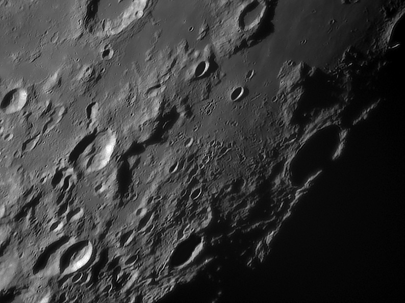
<p>This isn&#8217;t an inspiring piece of lunar landscape. Its the marshy southern shore where Mare Fecunditatis runs onto highland terrain that apparently lacks strong structural control. Its exactly the sort of place that people don&#8217;t image often enough, and it must have stories hidden away to tell us. First, what is that huge triangular mountain just above Wrottesley, enshadowed at center right? In the 1830s Madler named it Biot Beta, after the 13 km wide simple crater to its left. There are essentially no processes for making big mountains on the Moon except as rims of craters and basins. Sure enough, in Paul Spudis&#8217; book <em>The Geology of Multi-Ring Impact Basins</em> he uses Beta to help define the outer, 1320 km diameter ring of the Nectaris Basin. And notice the hilly ridge that goes from Borda (center left) to Biot B (flat-floored crater at top center) - that is the inauspicious [http://www.lpod.org/?m=20070508 continuation] of the main Altai Scarp ring of Nectaris. Now a detail. Notice the straight and narrow crater chain on the left side of Snellius A (shadow-filled, bottom center). That is a secondary crater chain, but from where? Nearby Snellius seems too old (and in the wrong direction), but younger [http://www.lpi.usra.edu/resources/lunar_orbiter/bin/info.shtml?121 Stevinus] is right in line. One final oddity - did you notice that the eastern bright rim crest of Wrottesley has a shadow right in its middle? Why do you think that is? What is just to the east? Its Petavius; Wrottesley formed on the rim of the larger crater, and that may have lowered the height of [http://www.lpod.org/?m=20061212 Wrottesley&#8217;s] eastern rim, accounting for the shadow. </p>
+
<p>This isn&#8217;t an inspiring piece of lunar landscape. Its the marshy southern shore where Mare Fecunditatis runs onto highland terrain that apparently lacks strong structural control. Its exactly the sort of place that people don&#8217;t image often enough, and it must have stories hidden away to tell us. First, what is that huge triangular mountain just above Wrottesley, enshadowed at center right? In the 1830s Madler named it Biot Beta, after the 13 km wide simple crater to its left. There are essentially no processes for making big mountains on the Moon except as rims of craters and basins. Sure enough, in Paul Spudis&#8217; book <em>The Geology of Multi-Ring Impact Basins</em> he uses Beta to help define the outer, 1320 km diameter ring of the Nectaris Basin. And notice the hilly ridge that goes from Borda (center left) to Biot B (flat-floored crater at top center) - that is the inauspicious [[May_8,_2007|Stevinus]] is right in line. One final oddity - did you notice that the eastern bright rim crest of Wrottesley has a shadow right in its middle? Why do you think that is? What is just to the east? Its Petavius; Wrottesley formed on the rim of the larger crater, and that may have lowered the height of [[December_12,_2006|Wrottesley&#8217;s]] eastern rim, accounting for the shadow. </p>
 
<p>[mailto:tychocrater@yahoo.com Chuck Wood]</p>
 
<p>[mailto:tychocrater@yahoo.com Chuck Wood]</p>
 
<p><strong>Technical Details:</strong><br />
 
<p><strong>Technical Details:</strong><br />

Latest revision as of 22:05, 22 March 2015

Uninspiring, but an Active History

MoonBorda080107.jpg
image by Bob Pilz

This isn’t an inspiring piece of lunar landscape. Its the marshy southern shore where Mare Fecunditatis runs onto highland terrain that apparently lacks strong structural control. Its exactly the sort of place that people don’t image often enough, and it must have stories hidden away to tell us. First, what is that huge triangular mountain just above Wrottesley, enshadowed at center right? In the 1830s Madler named it Biot Beta, after the 13 km wide simple crater to its left. There are essentially no processes for making big mountains on the Moon except as rims of craters and basins. Sure enough, in Paul Spudis’ book The Geology of Multi-Ring Impact Basins he uses Beta to help define the outer, 1320 km diameter ring of the Nectaris Basin. And notice the hilly ridge that goes from Borda (center left) to Biot B (flat-floored crater at top center) - that is the inauspicious Stevinus is right in line. One final oddity - did you notice that the eastern bright rim crest of Wrottesley has a shadow right in its middle? Why do you think that is? What is just to the east? Its Petavius; Wrottesley formed on the rim of the larger crater, and that may have lowered the height of Wrottesley’s eastern rim, accounting for the shadow.

Chuck Wood

Technical Details:
2007/08/01, Utime: ~09:17. 200mm f/6 Newtonian reflector, Televue 3x Barlow, DMK 21BF04 B/W camera, Blue IR-block filter, 30 fps, 1/44 sec, 600/9000 frames stacked with Registax V4; PS CS, Focus Magic. Taken from Lat: 35 degrees 36 minutes N, Long: 82 degrees 33 minutes W, Elev: ~850m.

Related Links:
Rükl chart 59
Bob’s website

Yesterday's LPOD: Limb Gift

Tomorrow's LPOD: Two Ancient Moons


COMMENTS?

Register, Log in, and join in the comments.