December 21, 2017
Percy Who?
Originally published June 22, 2008

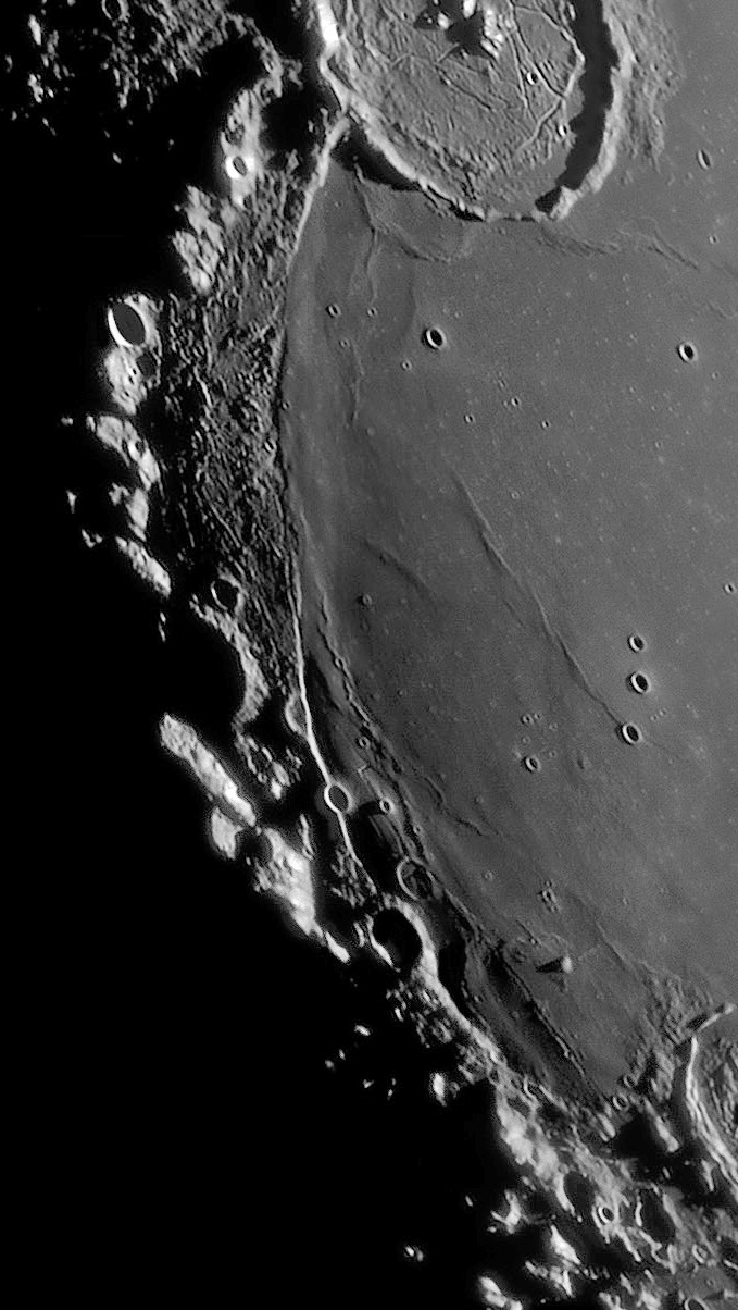
image by Paolo R. Lazzarotti, Massa, Italy
The western shore of Mare Humorum has a complex edge due to interactions with the basin's 425 km diameter rim. Paolo's image (a snippet from a larger one) shows the first light of the lunation shining on this rim. The portion that extends from Gassendi half way down the left side was named the Percy Mountains by the 19th century selenographer Birt, and used by Elger in his 1895 book, but the IAU stripped that useful name away. Walter Goodacre wrote that these mountains, when seen under a low sun, have the appearance of an archipelago rising from the surface of the surrounding sea. And the shadow cast by the edge of the smooth mare implies that it was formed by a wave of lava that washed over some of the hilly terrain adjacent to the rim. This textured material may be ejecta from the formation of the basin that fell back down onto the newly-formed floor. At both ends of the boundary between the smooth mare and the textured material there is a short segment of an apparent fault scarp (note the crater cut in half in the south) showing that the edge of Humorum's floor faulted downward and didn't just sag. A series of narrow straight rilles with domed sides cut the mare near the southern end of the rim, perhaps formed by rising dikes of magma that followed basin-formed fractures to the surface. A higher sun reveals a dark patch around some of these rilles, evidence for pyroclastic eruptions too.
Chuck Wood
Technical Details
Feb 17, 2008, 21:06-21:17 UT. Gladius CF-315 Lazzarotti Optical telescope + LVI-1392 PRO experimental camera + Edmund Optics R filter, 40/2000 frames.
Related Links
Rükl plate 51
Yesterday's LPOD: Ultimate Pans
Tomorrow's LPOD: An Older Tycho
COMMENTS
1. W.R.Birt's Percy Mountains and the western "coastline" of Mare Humorum were also photographed during the mission of Apollo 16 (orbital Hasselblad photographs; looking south with Gassendi in the foreground). In these orbital images, the morning terminator's location was almost the same as in Paolo Lazzarotti's image. Magnificent photographs! Worthwile to create a mozaic of them! (an overview of the whole area with Gassendi and Gassendi A, aka Clarkson). Harold Hill made wonderful drawings of that area (of M.Humorum's western "coastline").
-- Danny Caes.
2.
Chuck: That fault scarp you mention is as you know Rupes Liebig that Paolo has wondefully captured, but I'm wondering about its formation -- did it fault first and then came the domed straight rilles from, as you suggest, rising dikes of magma, or, could this latter effect have caused the fault itself? I understand that the natural trend for faults to occur around basin edges is due to subsidence as the source plume relaxes, however, I picture the lava shelf (having cooled along the edge) being put under pressure as the plumes rose up underneath along the rille areas. This would cause a contraction-like effect on the shelf's edge (similar, I guess, to the subsidence effect); producing the fault we see today. John -- www.moonposter.ie (still down due to new host setup)
COMMENTS?
Register, Log in, and join in the comments.


